Publicador de contenidos

Why the Preah Vihear dispute between Cambodia and Thailand persists

Why the Preah Vihear dispute between Cambodia and Thailand persists: An international law analysis

ANALYSIS

30 | 06 | 2026

Texto

The border controversy concerns sovereignty over the disputed temple and its surrounding area; it is mostly a matter of ambiguity

En la imagen

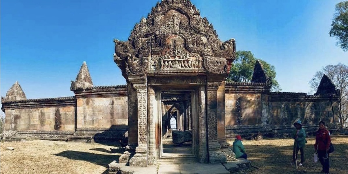
The Preah Vihear Temple [Tripadvisor]

On 27 December 2025, Cambodia and Thailand agreed on a ceasefire, after four months of violence along the border, since a major military confrontation between the two countries took place on 24 July 2025. However, the situation remains fragile, as underlying tensions persist despite the absence of direct armed confrontation. Those tensions escalated on 6 January 2026, when Thai forces accused Cambodians of violating the ceasefire, after one of their soldiers was wounded in a mortar attack, which was later claimed to be caused by “an operational error by Cambodian personnel.” Despite the explanations provided by Cambodia, the Thai army warned their counterparts that in case of another error, “Thailand may be compelled to carry out defensive countermeasures.” 

Origins of the dispute

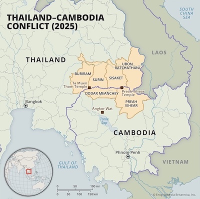
The border dispute concerns sovereignty over the Preah Vihear Temple and its surrounding area. To conduct a proper analysis, it is necessary to return to its origins: sovereignty over the Temple has been controversial since the early 20th century, when France and Thailand, named Siam at that time, signed in 1904 the “Convention between France and Siam for the Regulation of Certain Difficulties,” which drew the frontier lines between Siam and French Cambodia based on the watershed between the basins of two rivers: the Nam San and the Nam Moun. The Preah Vihear Temple was situated within Siam’s boundary, and no other demarcation was established.

In March 1907, a second treaty was signed to exchange some territories between France and Siam. The treaty led to the establishment of a Franco-Siamese Mixed Commission for the delimitation. However, those in charge of the mapping of the territory were French officials, as the Siamese lacked sufficiently qualified personnel, and the map drawn in 1908 was never officially accepted by Siam. On this “Annex 1 Map,” the Preah Vihear Temple was located on Cambodian territory, and the French gave no explanations for that sudden change of the frontier line. Cambodia maintained this situation after its independence in 1953, leading to the adoption of different border maps by both countries.

In 1962, the ICJ ruled the Temple belonged to Cambodia, ordering the withdrawal of Thai forces and banning any military or police activity by Thailand that could infringe on Cambodia’s sovereignty over the Temple. The main argument invoked by the court was the tacit acceptance of the 1907 map by the Siamese Government and later the Thai Government: Siam used and published maps which show the location of the Temple in Cambodian territory, and neither during negotiations for the 1925 and 1937 Franco-Siamese Treaties, nor in Washington in 1947 before the Franco-Siamese Conciliation Commission did Siam raise the matter. Furthermore, Siam did not react when in 1930 Prince Damrong, on a visit to the Temple, was officially received by the French Resident for the adjoining Cambodian province. Only decades later, during its negotiations with Cambodia in Bangkok in 1958, did the Thai Government raise the issue of the Temple. 

Although Thailand complied with the ICJ ruling, it erected a wire fence in July 1962, which separated the Temple from the surrounding area. The reason for this was that, due to the failure of the ICJ to rule on the boundary lines between the two countries, Thailand perceived that even though Cambodia owned the Temple, the surrounding area was under Thailand’s sovereignty.

The border dispute became less relevant after Vietnam invaded Cambodia in 1978. In the early 1990s, following Cambodia’s stabilization, both states agreed to manage the dispute through short, mid and long-term mechanisms: in the short-term, the two countries created the General Border Committee (GBC) and the Regional Border Committee (RBC), respectively led by defense ministers and military commanders, with the aim of containing conflicts but not resolving the dispute. In the long-term, Foreign Ministers of Thailand and Cambodia established a “Joint Boundary Commission” in a joint cabinet meeting in Siem Reap, Cambodia, in 1997, which carried out significant work in relocating boundary pillars, based on the boundary demarcations of the 1904 and 1907 Treaties and the Annex 1 Map. This mechanism was useful to build trust and confidence between the countries. Finally, as a mid-term mechanism, Thailand and Cambodia signed a “Framework Agreement on Economic Cooperation” in July 2001. Moreover, they created a shared development zone along the border, the “Crescent Opportunity,” a project which connected seven provinces of each country (including Preah Vihear Province), forming a circle of cooperation and mutual benefit from this area. Thanks to this initiative, Phnom Penh and Bangkok signed an agreement in March 2004 to renovate the Preah Vihear Temple, as a symbol of friendship.

Resurgence of the conflict

In July 2008, the World Heritage Committee decided to put the Temple of Preah Vihear on the UNESCO World Heritage List, after Cambodia had proposed it in 2001. Thailand first supported a bilateral submission, but Cambodia moved towards a unilateral position. Nevertheless, Thai Prime Minister Samak Sundaravej still supported Cambodia in its initiative, which caused anger among Thai nationalists. Eventually, new armed clashes took place through occasional exchanges of fire in April 2009, October 2009, January 2010, April 2010, June 2010 and February 2011. The conflict escalated between 22 April and 3 May 2011. On 18 July 2011, after a previous request by Cambodia, the ICJ issued a preliminary decision demanding both countries to withdraw troops from the vicinity and the wider region of the Temple, creating a demilitarized zone. This never occurred and instead, both countries announced a redeployment of their troops in July 2011. 

The escalation was followed by years of calm until a Cambodian soldier was killed in a skirmish in May 2025. This began an increase in tensions, which culminated with major escalation of the conflict on 24 July, when cross-border fire took place between Thai and Cambodian soldiers in the disputed territory. The day before, a landmine explosion injured five Thai soldiers, and Thailand recalled its ambassador to Cambodia. At least 48 people were killed and thousands displaced during five days of fighting in July. Today, with the ceasefire signed on December 27 still in effect, Thai troops surround the Temple on three sides. Neither party has violated the agreement, but according to the US Mission in Thailand, the security situation is still unpredictable, as Thailand continuously tries to alter the status quo by carrying out unilateral military activities in disputed border areas.

Judicial settlement of the dispute

The border conflict between Cambodia and Thailand has become a relevant case from the perspective of international law. The International Court of Justice adjudicated the case in 1962 and later interpreted its judgment in 2013. 

On June 15, 1962, the ICJ ruled the Temple belonged to Cambodia. The Court established first that the sovereignty over Preah Vihear “depends upon a boundary treaty dated 13 February 1904, and upon events subsequent to that date,” which consisted of a delimitation process developed by the Mixed Commission, as well as a series of maps, being the Annex I map (in which the Temple appears situated on the Cambodian side) the one in which Cambodia based its claim of sovereignty over the Temple. Thailand argued the map had no binding force as it was not developed by the Mixed Commission, and that the frontier line indicated on it was not the watershed line. 

The Court indeed concluded the map had no binding character the moment it was produced. However, it did confirm its technical authority and official character. The decisive issue identified by the ICJ was whether Thailand accepted the map and its boundary line or not, and the Court answered this question very clearly: Thailand received and used the maps, and did not object either in the 1925 and 1937 Treaties of Friendship, Commerce and Navigation, nor in 1947 in Washington (Thailand did make complaints about the frontier line in several regions, but not about the Temple). Thus, the Court asserted Thailand acquiesced: ‘Qui tacet consentire videtur si loqui debuisset ac potuisset’ (He who remains silent is taken to agree, if he ought to have spoken and was able to do so). 

Thailand argued it did not have to raise the matter because it considered itself sovereign over the Temple, which was evidenced by the control exercised in the area. However, the Court found these acts to be limited and mostly local, not enough to outweigh long-term acceptance of the map. According to the judgment, the Court found it complicated “to regard such local acts as overriding and negativing the consistent and undeviating attitude of the central Siamese authorities to the frontier line as mapped.”

To provide a better understanding of the ICJ’s decision, it is essential to analyze it taking into consideration the ICJ’s hierarchical decision rule in territorial disputes: the Court looks first to treaties, then to ‘uti possidetis’ (a principle of international law which seeks to preserve the borders of new states emerging from former colonies), and finally to effective control. The existence of a treaty or any other agreement between states is generally dispositive for the ICJ. In this case, the 1904 Treaty and the tacit acceptance of the Annex I map were a manifestation of the states’ consent to the location of the Temple on the Cambodian side. This explains why the ICJ did not consider other factors such as geography, culture or ideology: international law does not act as a body of rules independent from state sovereignty, but respects agreements between sovereign states. The ICJ does not have the power to impose any rules on Thailand or Cambodia if they have previously agreed to manage their territorial affairs in a specific way.

In 2013, the ICJ interpreted its 1962 judgment, at the request of Cambodia. While Thailand believed there was a dispute around the execution of the Judgment, Cambodia claimed there was a disagreement regarding its interpretation, and more specifically, in terms such as the “vicinity” of the Temple, or Thailand’s obligation to withdraw. 

The ICJ interpreted that Cambodia had sovereignty over the whole promontory of Preah Vihear and Thailand had to withdraw its troops from that territory. The Court stated this territory did not include the one chosen by the Thai Council of Ministers in 1962, nor the zone interpreted by Cambodia, which included, apart from the promontory, the hill of Phnom Trap.

In this case, the scope of the 2013 interpretation was directly conditioned by the structural limitation of Article 60 of the ICJ Statute: “In the event of dispute as to the meaning or scope of the judgment, the Court shall construe it upon the request of any party.” An analysis of what this article implies is essential to understand the difference between an interpretation proceeding and a new judgment by the ICJ: Cambodia requested the Court to interpret its previous judgment, which meant that the ICJ was limited to clarifying those aspects of the 1962 judgment whose meaning or scope was genuinely in dispute, without any power to modify, revise, or expand the original decision. Therefore, the ICJ did not address questions such as the binding force of the boundary established by the 1962 Judgment, ownership of areas beyond the promontory of Preah Vihear, whether Thailand’s obligation to withdraw was a continuing one, or whether the Annex I map legally constituted the international boundary for all surrounding territory.

Remaining dispute 

The conflict between Cambodia and Thailand over the Preah Vihear Temple illustrates a common problem in judicial controversies: a lack of precision in defining the dispute. The International Court of Justice, the highest judicial authority in international law, has been unable to bring the conflict to an end, largely due to the lack of cooperation between the two states in presenting their claims before the Court. 

The principle of ‘ne ultra petita,’ according to which the Court cannot decide more than what the parties request, is essential to ensure the well-functioning of the judicial procedure and the proper respect for the sovereignty of states. In 1962, the Court was asked to decide territorial sovereignty over the Preah Vihear Temple, and thus, the judgment established the Temple belonged to Cambodia. In the 2013 interpretation, the Court confirmed Cambodia’s sovereignty over the whole promontory of the Temple and Thailand’s obligation to withdraw from that area. Nevertheless, sovereignty over the surrounding area (about 4.6 km²) is still disputed, as the Court was legally limited to decide the matters that were raised by the parties.

Overall, the remaining dispute over the territory around Preah Vihear Temple is mostly a matter of ambiguity. Although both countries have complied with the ICJ’s decisions, as Thailand respected Cambodia’s sovereignty over the Temple and, after the interpretation, over the promontory, they have not been able to reach an agreement regarding the disputed surrounding area. The conflict will only be settled when both countries agree on establishing a border or ask the ICJ to solve the remaining territorial disagreement, being the first option much faster and more flexible than the second one. Until that occurs, violent confrontations along the border are likely to remain unpredictable.

BUSCADOR NOTICIAS

BUSCADOR NOTICIAS

Desde

Hasta